The Takeaway: Learn how one small community is investing in different land use approaches such as open space preservation to reduce flooding, resulting in savings for flood insurance policy holders.
Overview
Known by locals as the “Edge of America,” Folly Beach, South Carolina, is a small barrier island with 2,400 residents and countless year-round visitors. “Being a barrier island means we deal with flooding on a weekly basis—flooding from high tides, rain, drainage, and storms,” says Eric Lutz, the city’s floodplain manager. A few years back the city made the critical decision to conserve a large portion of its natural resources to help reduce flood impacts.
“Almost every municipality can use zoning to help make their communities safer from coastal hazards,” says Spencer Wetmore, Folly Beach’s city administrator. Folly Beach conserved its marshes and beachfronts, which in turn helped reduce storm surge and other flooding impacts. This forward-thinking decision to conserve the marsh, among other flood preparedness activities, is paying off in a big way.
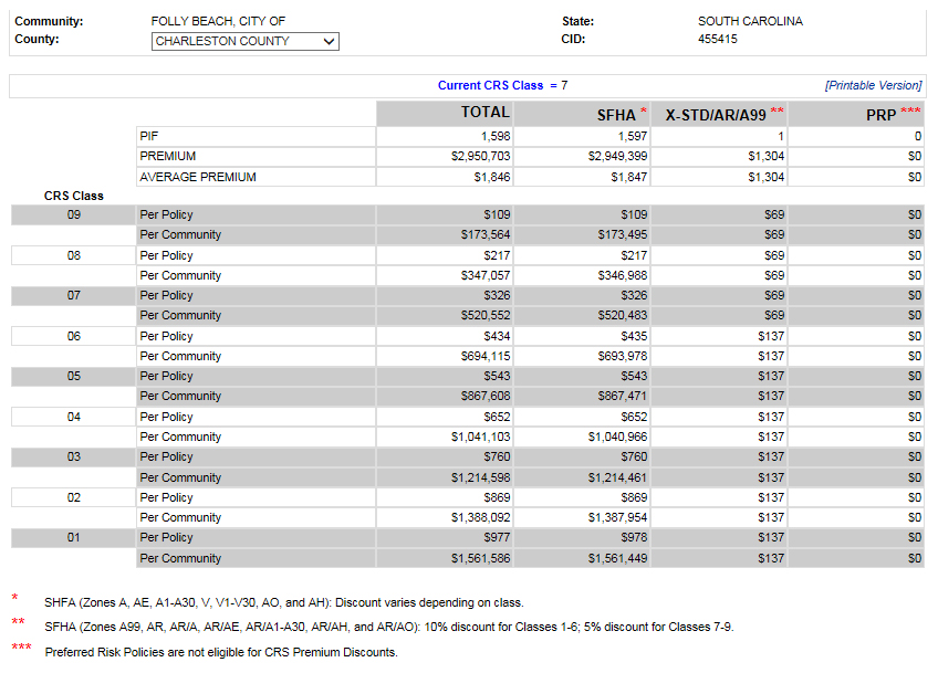
FEMA’s Community Rating System provides discounts on flood insurance for taking steps to reduce flooding and its impacts by implementing standards beyond the minimums of the National Flood Insurance Program (NFIP). As of May 2018, Folly Beach is a Community Rating System class 4 community. This equates to a 30-percent reduction in premiums for each flood insurance policy. The city is now saving $1,041,103 annually on the cost of flood insurance for its policyholders—or an average of $652 per policy, which is twice the savings per flood insurance policy as before. Before becoming a rating system class 4, Folly Beach was a class 7, which equated to a savings for the city of $520,552 annually, or an average of $326 per flood insurance policy.
“Luckily we have an eco-minded community that wants to protect its natural resources and its sense of place. What’s great about this [conservation] is that it also protects us against flooding impacts,” says Spencer.

Lessons Learned
- Use terms that resonate with people. Focus on “flooding” instead of “climate change” or “sea level rise.” For instance, “We know flooding is a critical problem that needs solutions now,” and “We have to address flooding, whether the sea rises one, two, or three feet over the next 100 years.”
- Make the commitment to do flood mitigation and keep going. The city’s success hasn’t happened overnight. They committed to protecting the community through flood mitigation, which is also helping to protect Folly Beach’s sense of place.
- Hire a professional to help with the Community Rating System documentation. Having someone who knows the ins and outs of the program and exactly which documentation is needed is well worth the investment.
- Use land use zoning. Almost every municipality can use zoning to help make their neighborhoods safer from coastal hazards.
The Process
Folly Beach did the work, but it needed to put an application package together for the Insurance Services Office, Inc. specialist for South Carolina in order to get the Community Rating System credits. The system’s process requires specific and detailed documentation to support receiving credit for each activity. To help with the documentation, they hired David Stroud, a certified floodplain manager with the Wood Group, who has worked extensively with the Community Rating System program.
Eric Lutz, the city’s floodplain manager, had met David a few years back at a conference. Eric mentioned that they wanted to improve their rating, and David asked, “How far do you want to go and what do you want to achieve?” David guided the city through the mapping and documentation process. He reviewed each current Community Rating System activity the city was implementing, and how each had changed from the 2007 Coordinator’s Manual (the document that guides a community’s application into the program) to the 2017 Coordinator’s Manual. He also identified which documentation needed to change to meet the requirements, and what additional activities—or elements within existing activities—could be added to gain more credits.
The objective was to undertake activities that the city was already implementing or could easily implement. In addition to the points for a class 4, the city also had to meet the class 4 prerequisites. View prerequisites list.
“My role is to help the city maximize their efforts and get the most credits,” David says, “and it comes down to having the exact documents needed by the Insurance Services Office, which verifies a community’s Community Rating System program for FEMA. The city is great to work with. They are hard workers and have put forth the effort to get to this Community Rating System class.”
Folly Beach officials initially aimed to be a Community Rating System class 6, but in the end, they got to a class 4, which equates to a 30-percent reduction in premiums for each flood insurance policy. The city is now saving $1,041,103 annually on the cost of flood insurance for its policyholders, or an average of $652 per policy. Folly Beach is a great example of how mitigation pays off; a new study on the value of mitigation by the National Institute of Building Sciences reports that for every $1 spent on mitigation, a community can save $6 in future disaster costs and up to $7 for flooding. Folly Beach is leading by example.
Folly Beach’s Nature-Based Community Rating System Activities
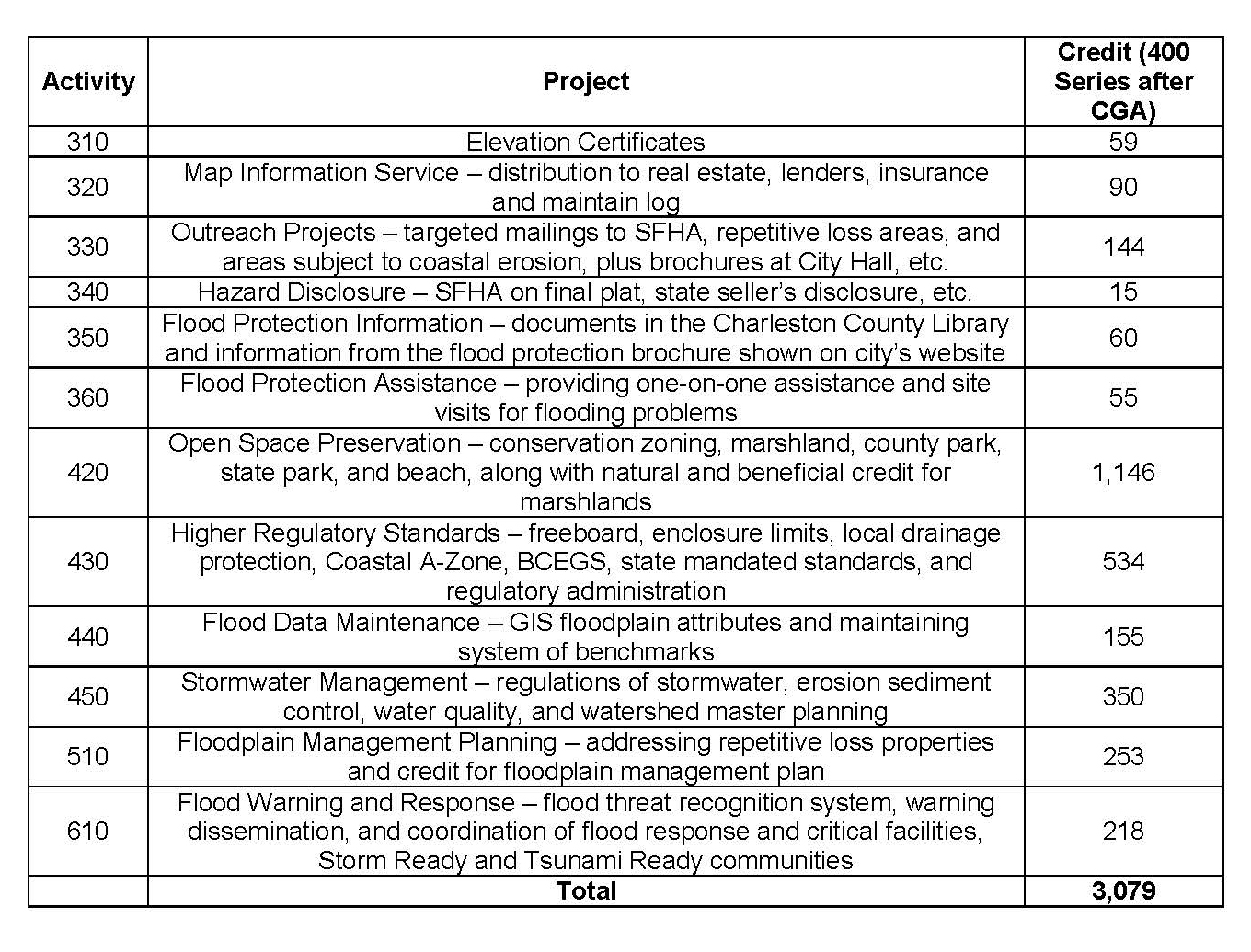
Folly Beach is using Community Rating System Activity 420–Open Space Preservation to obtain credits. Folly Beach has already zoned land as open space. This means new development is limited to boat docks and other similar uses. Folly Beach received 882 points of credit for conserving marshland, beach frontage, and the county parks. This means that 63 percent of the special flood hazard area is open space. The maximum credit for Open Space Preservation is 1,450 points.
The city is also getting credit under Community Rating System Activity 420c–Natural Functions Open Space. “We worked with South Carolina Office for Ocean and Coastal Resource Management to certify that the marsh was providing natural floodplain functions like absorbing water, habitat for loggerhead sea turtle nesting, and buffering waves,” says Eric. As a result, Folly Beach received 132 points for this activity. The maximum credit for Natural Functions Open Space is 350 points.
The combination of Open Space Preservation and Natural Functions Open Space credits provided 1,014 points for Activity 420 before the Community Growth Adjustment Factor—a growth value applied to all 400 series activities. Conservation zoning and protecting marshlands helped the city achieve its lower Community Rating System classification.
Other Flood Mitigation Activities
The city took advantage of the 300 series activity–Public Information Activities (Education and Outreach), other 400 series activities (Higher Regulatory Standards), and 500 series activities (Flood Damage Reduction). (See the table of activities at the end of this report for more details.)
Folly Beach also benefits from flood reduction activities that Charleston County is already getting credits for under the Community Rating System. Folly Beach operates under Charleston County stormwater and its MS4 program (municipal separate storm sewer systems), and benefits from the countywide stormwater management plan and regulations, the countywide hazard mitigation plan, and the county Flood Warning and Response program. These activities helped the city meet the required points and program prerequisites. Charleston County is a class 4 Community Rating System community as well.
The city also has an ordinance that limits the amount of pavement used in driveways to decrease stormwater runoff, and an ordinance that all new and/or substantially improved critical development be elevated to the 500-year (0.2 percent annual chance) flood elevation, or the highest known historical flood elevation. Residents are tuned in to the dangers and are supportive of floodplain management actions. “We get more questions now about why we are not doing more,” says Eric.
Additionally, to help limit future development in high-risk areas, the city works closely with the South Carolina Office for Ocean and Coastal Resource Management on development setbacks. Spencer says they “do a good job with the critical line (setback), and we look to them to lead us on their setbacks.” The city has a moratorium on building within 20 feet of the state’s critical line on the beach and marsh.
Outcome
In 2017, the city, with help from its planning commission, conducted a study to assess the impacts of both current and future flooding. The study identified three priorities: a drainage study, a marsh management plan, and a septic tank assessment. The study helped the council and residents realize the urgency to prioritize and fund the drainage study. Folly Beach will continue to focus on the marsh management plan and new ordinances related to setbacks and buffers.