Issue
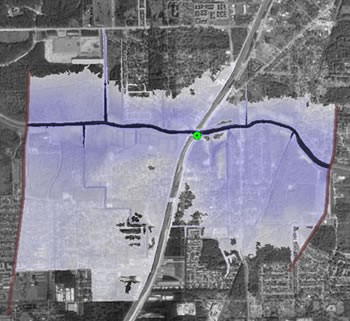
Flood forecasts from the National Weather Service (NWS) are used by emergency managers and city officials to prepare for and respond to the nation’s floods. Previously, the NWS published text-only flood forecasts informing users of river heights, but these forecasts lacked spatial information showing potential flood areas. Inundation maps with this information are necessary to inform road and bridge closures, mandatory evacuations, and the positioning of resources.
Process
Using high-resolution elevation data and reliable hydraulic models, state and federal partners mapped both the projected depth of floodwaters and the areas affected by inundation for several bayous near Houston, Texas. The models, available through Federal Emergency Management Agency (FEMA) Digital Flood Insurance Rate Maps (DFIRMS) and Flood Insurance Studies, were updated in 2001 after Tropical Storm Allison, allowing accurate modeling and mapping of water surface profiles. The data and resulting maps show how streets, buildings, airports, and other structures are likely to be impacted by floodwaters.
Impact
The maps allow decision makers to safely position assets, determine who to evacuate, and identify safe routes for moving people out of harm’s way during flood events. The maps are also being used for longer-term planning. Knowing the location and depth of potential floodwaters allows decisions to be made about modifying current infrastructure and safely planning future development, increasing a community’s resilience to natural disasters and mitigating the impacts of flooding.

