3D Model of Bay Sheds Light on Eelgrass Restoration Strategies
The Takeaway: A NOAA-supported analysis of California’s Morro Bay estuary found links between seagrass collapse and later erosion that will inform bay-area adaptation strategies and could influence global seagrass conservation strategies.
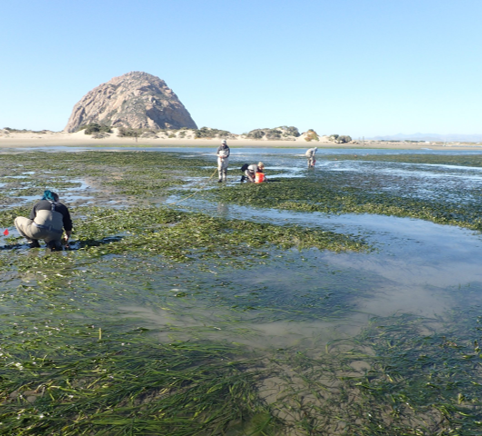
Abundant seagrasses foster estuarine life, resilience, carbon storage, and coastal economies—yet seagrasses are dying off at rapid rates across the globe. Project partners analyzing an estuary-wide eelgrass collapse in California’s Morro Bay discovered that erosion occurred in more than 90 percent of areas where the eelgrass formerly grew. A bay-wide adaptation model will leverage this discovery and others to pinpoint promising eelgrass restoration sites and lessen potential harm from sea level rise and habitat shifts.
The Morro Bay National Estuary Program and NOAA’s Office for Coastal Management co-led the project with the assistance of NOAA’s Coastal Geospatial Services Contract and funding from the U.S. Environmental Protection Agency and U.S. Fish and Wildlife Service. The data collection and 3D elevation model were made possible by Quantum Spatial, Inc., (now doing business as NV5 Geospatial) and its partner, Merkel and Associates.
These products add to the field’s scientific and management insights at a critical time. An assessment of 215 studies found that approximately seven percent of the world’s seagrasses are being lost each year because of development, polluted runoff, climate change, and other factors.
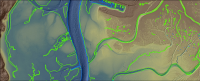
Eelgrass, tidal marsh, and sand spits can be very sensitive to changes in elevation. With this understanding in mind, the Morro Bay project partners collected seamless data of the area’s land features (topography) and the bay’s submerged features (bathymetry) using water-penetrating lidar from an airplane and ship-based sonar technologies. (Lidar and sonar both create detailed images of the seafloor.) The data also identify areas with the most promising depths for eelgrass transplanting.
Water-level monitoring stations enabled the partners to update circulation and water-dynamics data that expanded their understanding of bay sedimentation, water quality, and other factors that influence resilience and habitat conditions.
California Polytechnic State University-San Luis Obispo and partners published a paper on the relationship between Morro Bay’s eelgrass collapse and widespread erosion in Estuarine, Coastal, and Shelf Science.
The Morro Bay National Estuary Program is one of 28 estuaries of national significance and is a U.S. Environmental Protection Agency grant-funded program. NOAA’s Office for Coastal Management chose the contractors for this geospatial services contract and consulted on the data collection and modeling efforts. Read more about NOAA’s Coastal Geospatial Services Contract Vehicle, or contact coastal.info@noaa.gov. (2021)
Partners: California Polytechnic State University-San Luis Obispo, Merkel and Associates, Morro Bay National Estuary Program, NOAA Office for Coastal Management, Quantum Spatial, Inc. doing business as NV5 Geospatial, U.S. Environmental Protection Agency, and U.S. Fish and Wildlife Service.
PRINT