Issue
Maryland’s coastal zone is particularly vulnerable to episodic storms, shore erosion, coastal flooding, storm surge, and inundation. In Maryland, relative sea level rise is projected to be twice the global average rate. Land conservation efforts that accommodate and proactively target areas to allow for the inland movement of coastal habitat, such as wetland migration, are needed to help maintain natural storm surge buffers, wildlife habitat, wetland-dependent human activities, water filtration, and other ecosystem services wetlands provide.
Process
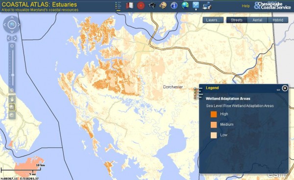
To better understand the impacts that sea level rise may have on the state’s coastal wetland system, the Maryland Department of Natural Resources (DNR) conducted wetland migration modeling using the Sea Level Affecting Marshes Model (SLAMM). DNR incorporated a variety of spatial criteria into the model to help identify coastal lands that provide adaptation opportunities under a sea level rise projection of 1.04 meters by year 2100. Using the results of the SLAMM projection for year 2100, DNR selected additional criteria to prioritize areas for land conservation, including criteria for maintaining these areas into the future: large continuous wetland areas, a diversity of wetland types based on projected wetland rates of loss, new wetland areas, and habitat type and size required by most wetland-dependent breeding birds. In addition, wetland areas were prioritized where they aligned with Maryland’s Green Infrastructure forest interior dwelling (FID) habitat, Blue Infrastructure watershed priorities, and suitable non-wetland hydric soils.
Impact
Maryland DNR is using the results of this analysis to target areas for land conservation that have adaptation benefits defined by the model criteria. In 2012, these Wetland Adaptation Areas were incorporated into Maryland’s GreenPrint application, which uses targeted ecological areas (TEAs) to locate the best-of-the-best ecological areas in the state for land conservation. In addition to targeting lands in the TEAs, DNR reviews every parcel of land that is considered for land conservation for potential climate adaptation benefits before seeking funding approval for land acquisition by the Maryland Board of Public Works. These benefits include protection of vulnerable areas, adaptation benefits, and mitigation.
The U.S. Fish and Wildlife Service, National Wildlife Federation, and Maryland Environmental Trust, along with other coastal land trusts, are also incorporating the resulting high-priority areas into land conservation planning, targeting, and parcel-level reviews to aid in climate change adaptation. Conserving these high-priority areas will allow habitats to shift inland naturally, protect developed areas, and allow places for wildlife to seek refuge as conditions change in the future.